

Mobile phones have powerful sensors to log detailed information through location tracking app and know about users' movements with their permission. Replaying the location timeline as a polyline on the map makes the journey come to life. Splitting the polyline of location history into activity segments helps understand the key moments in the journey.
Augmenting the activity segments with cool data like steps, distance and addresses gives useful context about the location accuracy in the journey. In case the device could not be tracked for a period of time, seeing those outage segments in the location timeline with precise reasons and locations makes it actionable to handle exceptions in location tracking.
Comparison with Google Maps location timeline
Some of you might be familiar with the location timeline feature in our Google Maps app (requires always on location access). We compared the HyperTrack's location timeline with Google Maps on the same device.
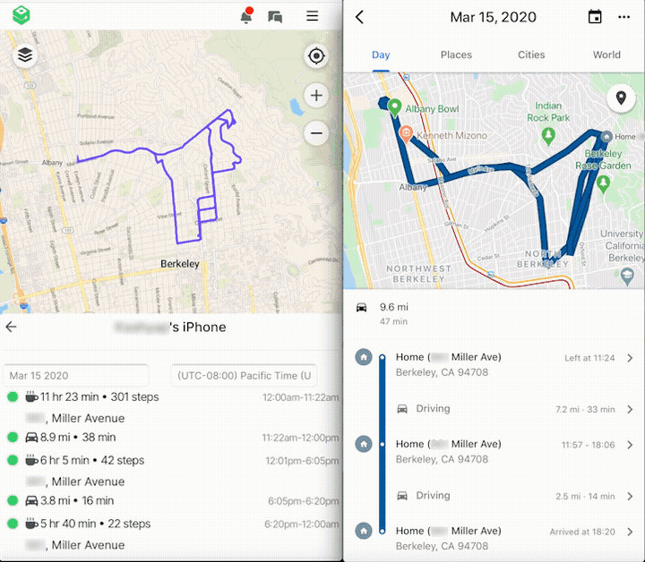
HyperTrack had far more granular data with location accuracy compared to Google. In the side-by-side screen recording above, Google Maps recorded a 14 minute drive of 2.5 miles with relatively straight lines. HyperTrack recorded the same drive as a 16 minute drive of 3.8 miles with higher location accuracy. The actual distance for the drive is accurate with HyperTrack and inaccurate by 30% with Google Maps.
Add location timeline tracking to any geolocation app
While Google Maps location timeline is available only through Google Maps app, HyperTrack is an SDK that may be added to any location tracking app. Location tracking controls are available through the server, and rely on explicit permissions from geolocation app users to protect user's privacy.
HyperTrack provides a detailed breakdown of the user's day including:
- Stops with addresses and steps during the stop
- Drives with accurate map-matched distances
- Walks with steps and distance
- Tracking outages (when we were not able to track the user)
With the HyperTrack SDK in your geolocation app, we harvest data from sensors like GPS and accelerometer through APIs made available by the phone Operating Systems. This data is securely ingested into the HyperTrack platform.
On the location tracking platform, we apply clustering algorithms and heuristics to understand device movement, and generate activity and outage markers in our location timeline summary.
Read more: Watch Out, Google Maps: With Amazon Location Service, The Location Cloud Is Here
Timeline for business on the move
The HyperTrack timeline gives you a deeper understanding of your business on the move. Dispute resolution, customer support escalations, expense management, timesheet automation, productivity and asset utilization are some use cases that users have implemented with the HyperTrack's asset tracking GPS. We track where and how your assets have spent their work day, and let you analyze and optimize your daily operations.
By nature, we track geographically distributed devices on phones controlled by your users. Even though we apply numerous techniques to ensure we track devices, there are circumstances that prevent us from location tracking. Tracking outages happen when location permission is denied, the app is deleted or killed, the phone is switched off or rebooted, the phone enters power saver mode due to low battery, and so on.
In case this happens, the location timeline shows you an outage with information when it started and ended, along with the outage reason. This gives you actionable insights about how to correct this and introduce location accuracy.
Also Read: 4 Myths about delayed deliveries and the realities of dealing with them
Integration with your application
HyperTrack timeline is available as web views that may be embedded in your web dashboards with useful customizations. Users may attach custom markers to the timeline through the asset tracking gps or geolocation app, or create trips to track specific journeys to a destination or geofences or geotagging. Timeline views or mileage tracking are available for individual trips as well.
Like all HyperTrack features, the timeline data is available through APIs. Separate API endpoints are available for devices and trips.
To get the data for a device, call the Device History REST API:
curl \
  -u {AccountId}:{SecretKey} \
  https://v3.api.hypertrack.com/devices/123E4567-E89B-12D3-A456-426655440000
/history/2020-02-02
And you will get receive a JSON object with a list of device_status markers that directly correspond to the timeline in our web views. See for example this snippet:
  ...
  "markers": [
    {
      "type": "device_status",
      "data": {
        "start": {
          "location": {
            "geometry": {
              "coordinates": [
                -123.4567,
                38.91234
              ]
            },
            "recorded_at": "2020-02-20T00:00:00.000Z"
          },
          "recorded_at": "2020-02-20T00:00:00.000Z"
        },
        "end": {
          "location": {
            "geometry": {
              "coordinates": [
                -123.4567,
                38.91234
              ]
            },
            "recorded_at": "2020-02-20T02:00:00.000Z"
          },
          "recorded_at": "2020-02-20T02:00:00.000Z"
        },
        "value": "active",
        "activity": "stop",
        "steps": 1491,
        "duration": 7200,
        "address": "123 Main St, Springfield, USA"
      }
    }
 ]
 ...
Experience it yourself
Product development teams around the world are building awesome mileage tracking applications and use cases with this rich movement data through geotagging . To experience it yourself, sign up for a HyperTrack account, get the HyperTrack Live app and see your location timeline in the HyperTrack dashboard.
We would love to hear about your experience, and help you bring your ideas to life with this data. To know more about eta tracking or mileage tracking, feel free to connect with us.

